Diphu April 3: The Ahom-ruled tract of the Brahmaputra river valley was the prime attraction for saints, invaders, interlopers, businessmen and preachers. The river Brahmaputra was militarized long ago during Ahom Rule. It was christened as the “highway of Assam.”
The river debauched into the Bay of Bengal and connectivity with the sea could give it a geopolitical advantage not used till the passages of the various powers. The British, through their Salt Trading business intruded deep into the secrets and ways of the way the Ahom administration functioned and this preceded the famous mission of Captain Welsh in 1793.
Captain Welsh Mission
The mission of Capt. Welsh was at the behest of the Ahom King beset with problems of multiple uprisings like the Moamaria in upper Assam and that in Darrang and Lakhimpur. Welsh was withdrawn as the policy of intervention in the neighboring countries was reversed.
However, the mission proved fruitful and quelling the unrest and uprising was achieved. Further, keeping the trading interest of the British East India Company, the Treaty of Kaliabor was inked. The comprehensive report by Captain Welsh is an example of a finest Intelligence report with details and various aspects.
Ahom rule lapsed back to a state of anarchy after the East India Company militia was withdrawn. Two thirds of the tract was depopulated. Imperial Burmese overtures in Assam (1818-1822) caused concern in Fort Williams. Captain David Scott was sent as a response to Rangpore and he consolidated his efforts by creating the Goalpara district in 1822.
Geopolitical Moves of British Imperialism
The imperialist Brits had an eye on Assam since the signing of the treaty of Sugauli . The lucrative routes through Nepal to Ladakh were lost in the process. Alternative routes were through the Chumbi Valley in Bhutan. The annexation of Assam (1826-1855) was useful in this exercise and on some pretexts, the Duar war (1864-1865) got underway, lasting nine months and nine days.
The treaty of Sinchula (by the river Rawa Khola) helped the British Indian authority to annex the entire Bengal, Kamrup and Darrang Bhutan Duars territory. These 18 Duars ( Lhas Sgo in Bhutanese) are where the critical Siliguri Corridor is located, along the foothills of Bhutan.
There are attributes of this area: Tea Estates of north Bengal, Raimona and Manas National Park, One Tiger Reserve and so on. The trade resumed through Bhutan Road after the British made contact in Lhasa with the Tibetan authorities. This sent a wrong signal to the Chinese who launched an armed invasion.
With Assam and Burma taken, the resources were there just ripe and waiting to be exploited. The forests gave way to the tea gardens with the commercial plantation of the tea tree of the native variety. It was identified by Nathaniel Wallach, a botanist in Calcutta Botanical Garden.

Tea plantation. Image by David Mark from Pixabay
Forests Cleared For Energy Resources
Also the axes cleared the forests for coal and petroleum. The Brahmaputra River was utilized for the steamer services which carried inward bound labor forces to the coolie lines of the new tea gardens; from the Gurkhali militia men to the Kaiyas, Nepalese grazers, tea tribesmen, the farmers of Bengal.
These communities made a beeline for this fertile valley which lost its population due to forced displacements during the episodes of Moamoria uprising and the Myanmarese atrocities on the Assamese population. Towards the end of the Second World War, the imperial Brits were apprehensive about the loss of colonial India, the ‘Jewel in the Crown’.
For its perpetuation, the ‘Crown Colony Scheme’ was made public in 1942. The Scheme was known as the Reid’s scheme. The proposed area included the Garo, Khasi, Jaintia , Mikir, Naga, Manipur, Lushai and the present day Arunachal Pradesh hills area as an appendage to the Burmese un administered tribal areas so that the area continues with the British Rule.
The rationales were two: On the lines of Christianity and that the hills people were not similar in culture, language and religion etc. No wonder, the Brahmaputra Valley and the Surma Valley were left out! The proposal did not get the nod and was turned down in 1946.
With the status of a nascent independent and democratic nation, India now inherited the geopolitical context with several inimical countries next across the international boundaries. Coming to the context of the North East, the very entity is geopolitically of utmost sensitive matter.
Pakistan and Bangladesh

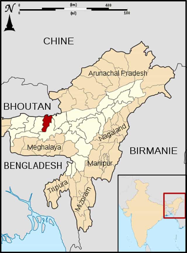
“Assam Nalbari locator map” by Sardon – travail personnel (own work) from File:India Assam locator map.svg. Licensed under Public Domain via Wikimedia Commons.
The dismemberment of Pakistan, subsequent creation of Bangladesh neutralized the threats, but contributed to a national headache and acidic stomachs. However, the un-administered areas of the Himalayan range were turned into the North East Frontier Agency.
The teething problem was the Monyul or the Monpa area. India annexed Tawang in 1951. The boundary issue turned with India’s stand about Tibet, Nehru’s Forward Policy and letting the Dalai Lama run his Tibetan Government on exile in India.
There were parleys over the border issue between China and India. They bogged down due to lack of proper maps. The ‘Longju incident’ ultimately fuelled the onset of the Indo Chinese war of 1962; India lost the war with world-wide humiliation.
The casualties, Missing in Action and Killed in Action were too high. The Chinese troops approached about 160 kilometers proximity to Tezpur and the same distance apart from the Digboi petroleum refinery. The ceasefire followed with an unexplained pull out from the occupied territory.
International Relationships
In a background like that the geopolitical seismograph is always active with the Indian Government’s ability to either mend or mess up the relationships with its neighboring countries. The best policy would have to rise up to the status of a regional hegemony.
Any policy with actions, if ill advised or ill construed, could negatively influence the security and integrity and the happiness index of the NE states.
Belt and Road
The internal Chinese proxy threats not withstanding, the imperialism of the communist China causes concern; the belt and roads project had its own impact across the McMahon line, a demarcation which the Chinese do not recognize.
At the same time, the alliances of the Chinese with Indian neighborhood countries are a bugbear and need good diplomatic action. Cross border terrorism keeps the Indian Special Forces on their toes in the western sector.
Vulnerable Sectors
In the extended sector West-East with Tibet China, the Western sector, the Sikkim-Bhutan combined sector and Arunachal Pradesh; the most vulnerable is the Sikkim Bhutan sector.
The Royal Bhutanese Army cannot be called a fighting army; the defense of the Chumbi Valley, if it fails, the Chicken Neck Corridor would be in danger. The north-east is dependent upon its quota of Salt to the Swords for its sustenance to defense.
Connectivity
The completion of the five projects by the BRO, the Border Roads Organization has bolstered the connectivity with the forward areas. The response matches the Roads and Belt project of the Chinese overtures. About the eastern neighbor, Myanmar, the Indian policies seem to be lopsided.
Insurgency
While alleged arms supplied from India is being utilized for mass genocide against the opposition by the army of the ruling military Junta, India is not benefitted with the super powers like the USA which has objected to this. The Indo-Burma Border was finalized in an agreement in 1968, only three to five pillars matter as a dispute.
The fencing of this terribly long distance to obviate the insurgency related issues from Myanmar has created ripples amongst the trans-boundary Nagas. The message is very aggressive in content. It is desirable to use the right field based intelligence to create a peaceful and friendly neighborhood in a geopolitically sensitive zone.
The Srilankan economic debacle caused the instability in their administration and public discontentment. This was engineered by the financial intrusion by the Chinese. It is a matter of time to see Bangladesh heading the same way.


